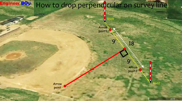
How to drop perpendicular on survey line in land surveying
- Concrete Cost Estimator
- Concrete Continuous Footing
- Landscape Bidding and Estimating
- Construction Cost Estimating
- Concrete and steel cost estimation
- Construction Cost Estimate Breakdown
- Construction Estimating Worksheet
- Home Construction Cost Estimate
- Estimate Pricing Sheet
- Sheet for General Contractor
- Construction Cost Estimate
- Labor Materials Cost Estimator
- Masonry Estimating Sheet
- Sheet for Building Contractor
- Construction Schedule Bar chart
- General Cost Estimator Sheet
- General Construction Estimate
- Building and Road Estimating Sheet
- Detailed expense estimates
- Door and Window Takeoff Sheet
- General Construction Cost Estimating Sheet

S.L. Khan, the renowned engineer comes up with another informative tutorial for the civil engineers and land surveyors.
In this exclusive tutorial, one can learn how to drop perpendicular on survey line.
Land surveying belongs to the method, profession, and science of correctly finding out the terrestrial or three-dimensional position of points and the spaces and angles among them, usually accomplished by licensed surveyors, and members of different building professions.
These points are generally remain on the surface of the Earth, and they are extensively utilized to establish land maps and boundaries for ownership, locations (building corners, surface location of subsurface features) or other governmentally required or civil law purposes (property sales).
Land surveying stands for the detailed study or inspection with the collection of information through observations, measurements in the field, questionnaires, or research of legal instruments, and data analysis required for planning, designing, and ascertaining of property boundaries.
Perpendicular offset in surveying - The measurements are captured at exact angle to the survey line known as perpendicular or right angled offsets. The measurements which are not prepared at exact angles to the survey line are known as oblique offsets or tie line offsets.
To learn step-by-step process to drop perpendicular on survey line, go through the following video tutorial.
Video Source: SL Khan

- Application of concrete calculator
- Roofing Calculator can streamline the roof estimating process
- House construction cost calculator
- Engineering column design excel spreadsheet
- Material Estimating Sheet with Excel
- Materials List and Cost Estimate Worksheet
- Concrete Slab Estimating Calculator Sheet
- Common types of foundations for buildings
- Online calculation of construction materials
- Estimating with Excel for the Small Contractor
- Concrete Beam Design Spreadsheet
- Virtual Construction Management app for construction
- Autodesk’s Project Skyscraper
- Reed Construction’s Reed Insight
- Manage your construction project documentation
- Costimator, the popular cost estimating software
- On Center Software for construction professionals
- Free Construction Estimating Software
- Plumbing Calc Pro
- Cost Estimate Worksheet
- HVAC Piping Quantity Takeoff Worksheet
- Construction Estimating Software Sheet
- Estimate Cost Templates
- Construction Punch List
- Construction cost estimating template consisting estimating basic
- Gantt Chart Template for Excel
- Download Civil Engineering Spreadsheets with Verification
- The Building Advisor Estimating and Budgeting Worksheet
- Spreadsheet for design of concrete bridge
- Construction Estimating Software Free


